

SpaceX teams working at Vandenberg Air Force Base in California were finalizing preparations Tuesday ahead of the launch of a Falcon 9 rocket Wednesday carrying a trio of Canadian-built radar observation satellites into orbit.
A few minutes after liftoff Wednesday morning, the Falcon 9’s first stage will return to a landing zone back at Vandenberg for SpaceX’s second onshore rocket landing in California.
The 229-foot-tall (70-meter) Falcon 9 rocket is set for launch at 10:17 a.m. EDT (7:17 a.m. PDT; 1417 GMT) Wednesday from Space Launch Complex 4-East at Vandenberg, a military base around 140 miles (225 kilometers) northwest of Los Angeles.
There is a 13-minute launch window for launch Wednesday, or else the Falcon 9 rocket will have to wait to fly another day.
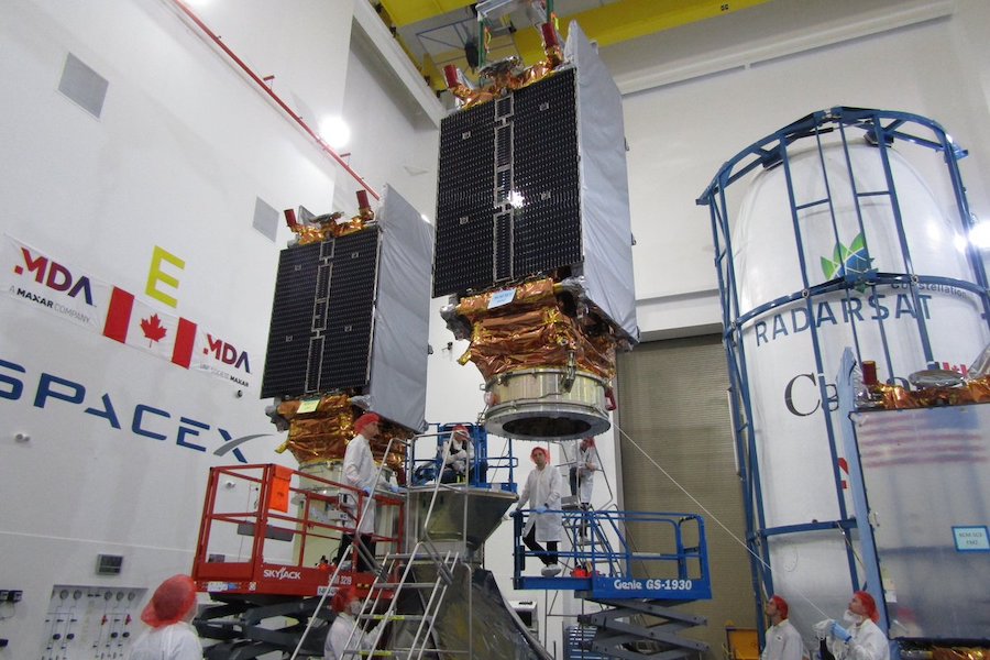
Three 3,152-pound (1,430-kilogram) spacecraft are packaged on top of the Falcon 9 rocket to continue a series of Canadian radar observation satellites launched since 1995.
The Radarsat Constellation Mission, or RCM, consists of three identical satellites built by MDA, a Canadian division of Maxar. The Canadian Space Agency leads the project to provide radar imagery to the Canadian government in pursuit of national security, scientific research and environmental monitoring.
“We still have a bunch of check milestones to go, but so far, so good,” said Mike Greenley, group president of MDA, in a phone interview Tuesday from Vandenberg Air Force Base.
The Radarsat Constellation Mission follows Canada’s previous radar observation satellites, Radarsat 1 and 2, launched in 1995 and 2007.
“It’s extremely important for Canada,” Greenley said of RCM.
The RCM project is costing the Canadian government roughly $900 million (1.2 billion Canadian dollars), including the development of the satellites, the launch, and seven years of planned operations, according to Steve Iris, the RSM mission manager at the Canadian Space Agency.
That makes RCM one of the most costly Canadian-led space missions in history, and one of the most expensive payloads ever launched by SpaceX.
Each RCM satellite carries a C-band radar instrument, with a deployable antenna array, transmitters and receivers.
Unlike optical cameras, radars can see through clouds and make observations day and night. The radar instruments emit signals and measure the waves reflected off Earth’s surface, yielding information about structures, ships, forests, ice, and crops.
“Earth observation is critical, and radar-based Earth observation gives Canada excellent capabiltiy to deal with the sovereignty and security of Canadians,” Greenley said.
A dozen Canadian government agencies, including the military, use Radarsat data. That broad use is expected continue with RCM.
“In addition to our resource-based economy requiring monitoring of our forests, mining, energy, and agricultural industries, our northern latitudes that are sensitive to climate change gain from space-based radar systems that can observe the Earth day and night in any weather conditions,” said Magdalena Wierus, a project management engineer on the Radarsat Constellation Mission at the Canadian Space Agency.
Most of Canada’s long coastline is located in remote regions of the Arctic, away from terrestrial observation posts.
“We have a large part of the northern part of Canada that has a low-density population, and there’s not a lot of infrastructure there to do monitoring, and that’s where there is the most impact from climate change, especially on the permafrost,” Iris said in a pre-launch press conference. “So with the constellation mission, we’ll be able to monitor that region every day, and monitor subtle changes like ground deformation due to permafrost melting. We’ll be able to do that four times a day, which is a big advantage compared to what we do now.”
When observing in spotlight mode, each of the three RCM satellites has a best resolution of 1 meter (3.3 feet) in azimuth, and 3 meters (9.8 feet) in range. That is comparable to Radarsat 2’s imaging power.
But with three satellites, RCM can cover more territory.
“It’s a three-satellite mission, each orbiting the Earth, evenly spaced, every 96 minutes at an altitude of approximately 600 kilometers (373 miles),” Wierus said. “One of the main improvements of the constellation is that together they’re able to ensure an exact revisit of a point on the Earth every four days, compared to Radarsat 2, which had an exact revisit of every 24 days.
“Now, why is this important? It’s because we can use these images to measure changes in ground movement, for example, which can help us understand what’s happening on the Earth better,” she said. “The RCM has the capacity to image any given location on 90 percent of the Earth’s surface daily, but will be primarily imaging Canadian territory.”
Along with maritime surveillance and environmental monitoring, the RCM satellites will track the movement of icebergs and the retreat and growth of glaciers and ice sheets. The observation satellites will also monitor natural disasters, such as floods, and detect water pollution.
“The main request of government users was to have daily coverage of the Canadian land mass and maritime approaches, including images of the Arctic four times a day,” Wierus said. “RCM is able to cover all of the regions of Canada within a 24-hour period, which was not possible with Radarsat 2.”
Wierus said the Canadian Space Agency is examining ways to distribute data collected by the Radarsat Constellation Mission outside the Canadian government, allowing international scientists, corporations and the public to access RCM’s imagery.
Besides the radar imaging sensor, each RCM spacecraft hosts a radio receiver to collect identification messages transmitted by maritime vessels.
“Overlaid on top of the radar images this can help pinpoint ships that may be in trouble, or rogue ships that do not want to be found,” Wierus said.
According to Greenley, MDA is supporting the Canadian government in the development of an open data access policy for RCM. Radarsat 2, which is still operational, is a commercial satellite that was partially funded by the Canadian government, with additional private sector investment from MDA, now part of Maxar.
MDA owns Radarsat 2, while the Canadian government owns the RCM satellites.
The Canadian government says it expects to use approximately 250,000 RCM images per year, more than the government’s demand for imagery from previous Radarsat missions.
Wednesday’s launch will be SpaceX’s seventh mission of the year, and the company’s second from Vandenberg in 2019.
After liftoff, the Falcon 9 rocket will head south over the Pacific Ocean powered by 1.7 million pounds of thrust from the the first stage’s nine Merlin 1D main engines, guzzling a mixture of super-chilled kerosene and liquid oxygen propellants.
The launcher set to loft the Radarsat Constellation Mission on Wednesday will use a first stage booster that previously flew March 2 on a mission from the Kennedy Space Center in Florida to send SpaceX’s first Crew Dragon spacecraft on an unpiloted test flight to the International Space Station.
At T+plus 2 minutes, 13 seconds, the first stage’s main engines will shut down, followed by separation of the booster around four seconds later. The Falcon 9’s second stage, powered by a single Merlin engine, will ignite at T+plus 2 minutes, 24 seconds, to accelerate the RCM satellites into orbit.
The protective composite shroud covering the RCM satellites during launch will jettison at T+plus 2 minutes, 49 seconds, once the rocket has soared above the dense lower layers of the atmosphere.
Meanwhile, the first stage will begin maneuvers to return to Vandenberg, beginning with a boost-back burn using three of the first stage’s Merlin engines to cancel out the rocket’s downrange velocity and reverse course back toward the launch site.
After the boost-back burn, the booster will reignite some of its engines for an entry burn, followed by ignition of the first stage’s center engine for a final braking maneuver as it descends toward a landing pad around a quarter-mile (400 meters) from the Falcon 9’s point of departure at Vandenberg Air Force Base.
After unfurling a four-piece landing gear, touchdown of the Falcon 9’s booster stage is expected around eight minutes after liftoff at Landing Zone 4, a circular concrete pad formerly known as Space Launch Complex 4-West, which was once a companion pad to the SLC-4E site first used by Titan rockets, and now by SpaceX’s Falcon 9 vehicle.
The rocket landing planned Wednesday will be the second onshore landing by a SpaceX Falcon 9 booster at Vandenberg, following the return of a first stage there last October after the launch of an Argentine Earth observation satellite.
SpaceX has logged thirteen additional Falcon 9 rocket landings at Cape Canaveral after launches from the East Coast, along with 26 successful returns to the company’s ocean-going drone ships.
The company warned that residents near Vandenberg may hear a sonic boom during the rocket landing Wednesday.
“There is the possibility that residents of Santa Barbara and San Luis Obispo counties may hear a sonic boom during the landing attempt,” SpaceX said in a statement. “Residents of Santa Barbara County are most likely to hear the sonic boom, although what residents experience will depend on weather conditions and other factors.”
The Falcon 9’s second stage will continue its mission with the RCM satellites, first placing the payloads into a preliminary parking orbit around eight-and-a-half minutes into the flight. After coasting over Antarctica, the upper stage will reignite for a short four-second firing around 50 minutes after liftoff to inject the RCM satellites into a nearly 373-mile-high (600-kilometer) orbit with an inclination of 97.7 degrees to the equator.
The satellites are mounted on a specially-designed dispenser manufactured by Ruag Space, a Swiss-headquartered company, with a tilt mechanism to ensure the RCM spacecraft have ample room to separate from the rocket in orbit.
The satellite separations are staggered about four minutes apart, with the last of the three scheduled for deployment 62 minutes into the mission.
Canadian ground controllers anticipate receiving the first radio signals from the satellites within two hours after launch to confirm the spacecraft are all alive and healthy.
The satellites will extend their flat panel radar antennas, each with an area of about 100 square feet (9.5 square meters), within the first couple of days of the mission, according to MDA. The radars will be powered on for the first time 10 or 11 days after launch, MDA officials said, to begin functional checks and take the first test images.
The full commissioning and calibration campaign will take three to six months, then the Canadian Space Agency will declare the RCM satellites operational and ready for regular observations, officials said.